http://www.independent.co.uk/news/science/sea-creatures-manmade-fibres-sea-pollution-deep-ocean-scientists-mariana-trench-newcastle-university-a8058106.html Tom Embury-DennisThursday 16 November 2017 13:12 GMT
Shocking results show there is nowhere untouched by scale of human waste
Scientists found traces of manmade fibres and plastics in the stomachs of sea creatures living at the bottom of the deepest ocean on Earth, in a concerning world first.
The shocking results show no part of the world’s oceans now remains untouched by human waste.
Scientists from Newcastle University tested crustaceans at the bottom of the Mariana Trench, known as Challenger Deep. At 10,890 metres below sea level it is the remotest part of the world’s oceans.
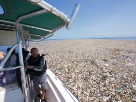
Tide of plastic rubbish discovered floating off idyllic Caribbean island coastline
Each creature was found to have ingested some form of manmade material, including the plastics Nylon, PVC, and PVA.
Dr Alan Jamieson, professor in marine ecology and the study’s lead, said the results were “immediate and startling”.
“There were instances where the fibres could actually be seen in the stomach contents as they were being removed,” he said.
“We felt we had to do this study given the unique access we have to some of the most remote places on Earth, and we are using these samples to make a poignant statement about mankind’s legacy.”
The team tested 90 crustaceans in the ultra-deep trenches spanning the Pacific Ocean - the Mariana, Japan, Izu-Bonin, Peru-Chile, New Hebrides and Kermadec trenches.
All were found to have creatures that had eaten some form of artificial fibre or plastic, ranging from 50 per cent in the New Hebrides to 100 per cent in the Mariana.
Deep-sea animals which will eat “just about anything” are dependent on food raining down from the surface.
“Litter discarded into the oceans will ultimately end up washed back ashore or sinking to the deep-sea, there are no other options," Mr Jamieson said.
“Once these plastics reach the deep-sea floor there is simply nowhere else for them to go, therefore it is assumed they will simply accumulate in greater quantities.”
“This is a very worrying find. Isolating plastic fibres from inside animals from nearly 11km deep just shows the extent of the problem.”
“This is global,” he added.
Elena Polisano, Oceans Campaigner for Greenpeace UK, told The Independent: “Plastic waste has been discovered just about everywhere. It’s in the Arctic, the middle of the Pacific, the bottom of the Marianas Trench, in whales, turtles and up to 90 per cent of sea birds, and also in our table salt, our tap water and our beer.
"We’re producing more and more of the stuff, and it will last for centuries. This isn’t about irresponsible individuals littering, this is about an industry churning out trillions of single-use disposable plastic items – bags, bottles, packaging - with no thought for the consequences. We urgently need to rethink how we use plastic.”
More than eight million tonnes of plastic goes into the oceans every year. With an estimated 300 million tonnes of it now littering our seas, it is estimated there will be more plastic than fish by 2050.
It is thought our seas now contain about 51 trillion microplastic particles – 500 times more than the number of stars in our galaxy.
This pollution is harming more than 600 species worldwide amid what many are now regarding as the sixth mass extinction of life on Earth
http://ekonomi.kompas.com/read/2017/11/22/090700026/ketika-teknologi-bambu-bisa-atasi-banjir-dan-tanah-longsor ALEK KURNIAWAN Kompas.com - 22/11/2017 Alek Kurniawan Bambu digunakan sebagai tanggul untuk mengatasi masalah banjir di Sungai Cijangkelok, Kabupaten Kuningan.
KOMPAS.com - Sudah sejak lama masyarakat di Kabupaten Kuningantepatnya di bantaran Sungai Cijangkelok di Desa Citenjo merasa khawatir ketika musim hujan datang.
Hal ini diakibatkan oleh bencana banjir yang kerap melanda daerah tersebut. Salah satu bencana yang masih terkenang dalam ingatan warga adalah banjir pada Januari 2017.
“Saya masih ingat waktu itu 22 Januari 2017 pukul 12.00 siang. Hujan turun sangat lebat. Pukul 02.00 pagi hujan reda, pukul 04.00 pagi hujan lebat turun lagi. Hujan berlangsung 3-4 jam,” ujar petugas Operasi dan Pemeliharaan Daerah Aliran Sungai (OP DAS) Cisanggarung, Kuningan, untuk Sungai Cijangkelok, Yayat Sudiyatna.
Yayat juga menjelaskan, pada sore harinya, permukaan air sungai mulai meluap dan luber sampai ke permukiman warga.
“Air banjir ini mencapai satu meter dan menggenangi tujuh desa. Desa Citenjo merupakan yang terparah,” tambah pria yang bekerja memantau proyek bioengineering di bantaran Sungai Cijangkelok ini.
Melihat kondisi tersebut, Direktorat Jenderal Sumber Daya Air (Ditjen SDA) Kementerian Pekerjaan Umum dan Perumahan Rakyat (PUPR) melalui Balai Besar Wilayah Sungai (BBWS) Cimanuk Cisanggarung memberikan perhatian khusus terhadap Desa Citenjo.
Sebulan berikutnya, yakni pada Februari 2017, dibangunlah tanggul oleh BBWS Cimanuk Cisanggarung yang bekerja sama dengan masyarakat setempat untuk mencegah banjir susulan.
Yang dibangun ini bukanlah tanggul pada umumnya, melainkan tanggul yang terbuat dari bambu dengan metode bioengineering.
Alek Kurniawan Bambu yang ditanam ini berfungsi untuk menahan air sungai yang meluap dan menyebabkan banjir di Desa Citenjo, Kab. Kuningan, Rabu (15/11/2017).
Dalam bahasa Indonesia, bioengineering dapat diartikan menjadi rekayasa hayati.
Melansir laman Institut Teknologi Bandung (ITB), Senin (20/11/2017), rekayasa hayati merupakan disiplin ilmu yang diaplikasikan dalam perekayasaan berbasis biosistem (gabungan ilmu biologi, lingkungan, dan pertanian) untuk meningkatkan efisiensi fungsi dan manfaat biosistem itu sendiri.
Pengaplikasian ilmu rekayasa hayati memang jarang terlihat keberadaannya secara kasatmata. Namun ternyata, bidang ilmu tersebut membawa banyak manfaat bagi masyarakat.
“Pada Februari 2017, kami menanam bambu sepanjang 300 meter di bantaran Sungai Cijangkelok untuk pembuatan tanggul alami.
Bambu kami pilih karena tanaman ini cocok dengan unsur tanah di sini dan dapat menahan erosi air sungai yang meluap,” kata petugas pembuat komitmen (PPK) OP III BBWS Cimanuk Cisangarung, I Gusti Ngurah Antariza.
Selain itu, Antariza juga menjelaskan, metode bioengineering ini dipilih untuk mengembalikan fungsi vegetasi lahan sungai dan secara otomatis dapat merestorasi agar tanggul sungai kembali hijau.
“Metode ini juga dipakai untuk meminimalkan dana. Proyek yang berjalan selama 3 bulan ini hanya menghabiskan dana APBN Rp 200 juta,” lanjut Antariza.
Saat ini, proyek bioengineering di Desa Citenjo sudah selesai 100 persen. Bambu yang tertanam semakin rapat dan lebat sehingga diharapkan bisa menahan air sungai yang meluap.
Selain bisa mengatasi masalah banjir di Desa Citenjo, Kabupaten Kuningan, ternyata metode bioengineering bambu ini juga digunakan untuk menanggulangi tanah longsor di bantaran Sungai Cigora, Desa Bandungsari, Kabupaten Brebes.
BBWS Cimanuk Cisanggarung Pembangunan tanggul di bantaran Sungai Cigora, Desa Bandungsari, Kabupaten Brebes saat dibangun.
Pada awal tahun 2017, bantaran sungai yang juga berbatasan dengan jalan antar-provinsi ini longsor sehingga jalan yang menghubungkan Provinsi Jawa Barat dan Jawa Tengah terputus sementara.
Setelah jalan diperbaiki, BBWS Cimanuk Cisanggarung kembali menerapkan metode bioengineering dengan tanaman bambu untuk menahan tanah yang longsor.
“Meski metode yang digunakan sama dengan yang di Kuningan, pembuatan tanggul di sini melalui dua tahap. Pertama, pembangunan tanggul tepat di pinggir sungai. Kedua, pembuatan tanggul di batas sungai dengan jalan raya,” ujar pelaksana teknis PPK OP III BBWS Cimanuk Cisanggarung, Muhammad Cucu Sudiyan.
Untuk tanggul di pinggir sungai, konstruksi yang digunakan adalah pemasangan batu dan karung berisi pasir serta penanaman cerucuk bambu di antaranya.
“Kemudian untuk tahap keduanya kami menanam bambu dengan jarak beberapa sentimeter. Lalu pada jarak yang kosong tersebut, kami tanami rumput vetiver (akar wangi) yang berfungsi untuk mencengkeram tanah sampai kedalaman 3 meter,” tambah Sudiyan.
Selain itu, ditanami pula tumbuhan kaliandra yang berguna menyedot air dan menahan butir-butir tanah yang tergerus. Terakhir, terdapat tanaman pandan laut yang bisa menahan longsoran tanah.
BBWS Cimanuk Cisanggarung Bambu yang sudah ditanami pandan laut, rumput vertiver, dan kaliandra diharapkan dapat mengatasi tanah longsor di Kabupaten Brebes.
Proyek yang berjalan mulai Februari hingga April 2017 tersebut pun sudah dirasakan manfaatnya pada musim hujan ini. Belum ada lagi tanah yang longsor.
Ke depannya, BBWS Cimanuk Cisanggarung menargetkan pembangunan lanjutan sepanjang 500 meter di bantaran sungai tersebut sehingga cakupan area yang terlindungi semakin banyak.
Ditjen SDA juga berharap bisa menerapkan metode bioengineering bambu ini di seluruh wilayah Indonesia. Dengan demikian, manfaatnya dapat dirasakan oleh semua kalangan masyarakat.
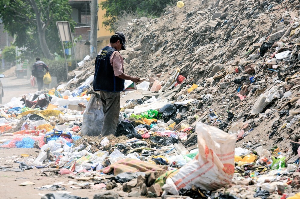
Masalah sampah di Indonesia menjadi salah satu perhatian utama bagi pemerintah. Sebab Indonesia saat ini dikenal sebagai negara kedua dunia yang memproduksi sampah dan mencemari lautan. Oleh karena itu pemerintah RI kemudia menggandeng empat negara yang telah memiliki kemampuan baik dalam manajemen sampah yakni Swedia, Finlandia, Norwegia, dan Denmark untuk mengolah sampah secara lebih baik. Rencananya, sampah-sampah di Indonesia akan banyak diolah menjadi listrik dan aspal.
Seperti diberitakan KataData (11/9), Menteri Koordinator Bidang Kemaritiman, Luhut Binsar Pandjaitan mengatakan bahwa keempat negara tersebut merupakan negara yang memiliki pengalaman dalam pengelolaan sampah. Diharapkan dengan kerjasama ini Indonesia akan dapat menghadapi kendala manajemen sampah baik dari aspek pendanaan maupun pendekatan politis. Sebab selama ini, pengelolaan sampah merupakan kewenangan pemerintah daerah.
Berdasarkan laporan Bank Dunia, biaya yang dikeluarkan untuk pengelolaan sampah di Indonesia baru US$ 5 - 6 per jiwa per tahun. Padahal biaya yang direkomendasikan adalah US$ 10 - 15 per jiwa tahun. Oleh karena itu, Indonesia akan melakukan perbaikan dalam manajemen sampah dan berkomitmen untuk mengurangi jumlah sampah sebesar 70% di tahun 2025.
Komitmen tersebut dilakukan dengan cara menguasai teknologi pengolahan sampah. Teknologi tersebut dapat diraih dengan alih teknologi dari empat negara yang tergabung dalam kerjasama. Sehingga pengelolaan sampah di Indonesia nantinya dapat menghasilkan energi listrik dan dapat diubah menjadi bahan baku aspal.
Menurut penelitian, aspal yang menerima campuran sampah plastik memang diklaim memiliki kualitas yang lebih baik dari aspal biasa. Dan ternyata metode ini telah diuji coba di Bali. Rencananya, pada bulan Oktober, metode serupa juga akan dilakukan di Bekasi.
Tidak hanya menjadi energi dan bahan baku aspal, sampah plastik juga akan diolah menjadi bahan baku membuat chip komputer. "Jadi banyak nilainya. Kami ingin menguasai teknologi ini," ungkap Luhut.
https://www.theguardian.com/cities/2017/sep/25/what-flood-proof-city-china-dhaka-houston?CMP=Share_AndroidApp_Tweet#59d0e746293c1 by Sophie Knight The wetter the better. From sponge cities in China to ‘berms with benefits’ in New Jersey and floating container classrooms in the slums of Dhaka, we look at a range of projects that treat storm water as a resource rather than a hazard
They call it “pave, pipe, and pump”: the mentality that has dominated urban development for over a century.
Along with the explosion of the motorcar in the early 20th century came paved surfaces. Rainwater – instead of being sucked up by plants, evaporating, or filtering through the ground back to rivers and lakes – was suddenly forced to slide over pavements and roads into drains, pipes and sewers.
Their maximum capacities are based on scenarios such as 10-year storms. And once they clog, the water – with nowhere else to go – simply rises.
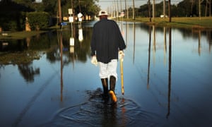
The reality of climate change and more frequent and intense downpours has exposed the hubris of this approach. As the recent floods from Bangladesh to Texas show, it’s not just the unprecedented magnitude of storms that can cause disaster: it’s urbanisation.
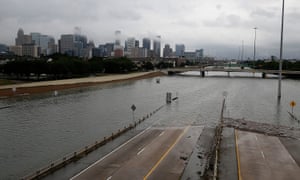
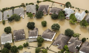
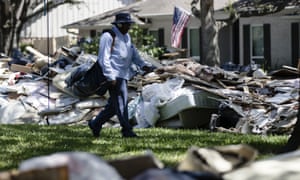
Hurricane Harvey displaced more than one million people, resulted in at least 44 deaths and damaged 185,000 homes in Houston alone
The US National Weather Service said the “breadth and intensity” of the rainfall that came with Hurricane Harvey in late August was “catastrophic”, and “beyond anything experienced before” – the city was overwhelmed with devastating speed, as can happen in areas where much of the land is paved.
A recent survey of global city authorities carried out by the environmental non-profit CDP found 103 cities were at serious risk of flooding.
With climate change both a reality and threat, many architects and urbanists are pushing creative initiatives for cities that treat stormwater as a resource, rather than a hazard.
PERMEABLE PAVEMENTS: CHICAGO'S 'GREEN ALLEYS'
One city already preparing for a climate future – or present - is Chicago, parts of which saw almost 20cm of rain in four days this July. It is projected to have 40% more winter precipitation by the end of this century.
The city has poured significant investment into reimagining stormwater management over the last decade, including building more than 100 “Green Alleys” – permeable pavement that allows stormwater to filter through and drain into the ground – built since 2006.
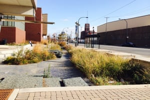
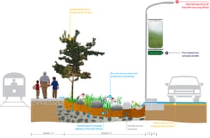
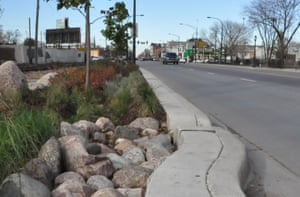
The most advanced is the two-mile “sustainable streetscape” across Cermak Rd and Blue Island Ave in Pilsen, in Chicago’s Lower West Side. Once a crumbling asphalt strip inclined to flood, today it is “the greenest street in America”: a $15m showcase for cutting-edge ecological technologies such as photocatalytic cement to reduce smog and landscaped shallow troughs known as bioswales, which act as environmentally-friendly drainage, filtering and absorb polluted water.
On the Pilsen Sustainable Street, rainwater travels through the sidewalk to porous rock, where it is decontaminated by microbes. It then goes onto feed surrounding plants, or it filters through sand deep in the ground to make its way back to Lake Michigan.
Rainwater travels through the self-cleaning, pollution-reducing sidewalk before going on to feed surrounding plants
In this way, 80% of rainfall is diverted from the sewage system, and the road no longer floods, says Jay Womack, a senior landscape architect at Huff & Huff, which was commissioned to design the street.
“We try to create porosity and permeability so that water can move in the ways that it moves in the hydrological cycle,” says Womack. “It’s very simple, but it’s very difficult for people to grasp, because we’ve not designed like that in a century.”
SPONGE CITIES: A NEW MODEL FOR CHINA
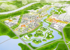
Lessons from Chicago are being applied in China, where the government has commissioned the construction of 16 “Sponge Cities” to pilot solutions for the freshwater scarcity and flooding suffered in many cities as a result of rapid urbanisation. Chicago architectural firm UrbanLab was commissioned to design the masterplan for Yangming Archipelago in Hunan province: a new centre within the larger city of Changde, devised as a “new model for the future”.
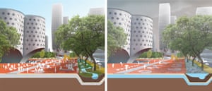
Changde’s ‘Eco-Boulevard’, in dry conditions (left) and wet (right)
The area, a low-lying land river basin that experiences heavy rainfall, is regularly flooded. Instead of incorporating defences against water, UrbanLab put space for it to flow at the centre of its urban plan, putting major buildings on islands in an enormous central lake. Canal-lined streets that UrbanLab call “Eco-boulevards” connect the eight districts – the process is visualised in this video.
UrbanLab says their vision combines a dense metropolis with a nature setting: “As a functional center, Yangming Archipelago will serve as an urban model, we expect it to lead the way to a new way of thinking about the city of the future.”
COASTAL CORRIDORS: NO MORE 'HOLDING THE LINE'
With 2.5 million residents of New York and New Jersey currently living within a designated flood zone, the Tri-State Region of the US is already vulnerable to flooding, and the outlook will only deteriorate with rising sea levels.
A cross-discipline team was commissioned by the Regional Plan Association and the Rockefeller Foundation to devise a response to the pressure put on the region’s coastlines within 50 years and six feet of sea-level rise.
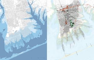
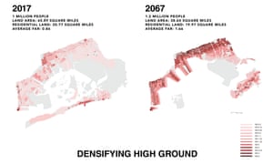
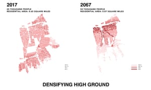
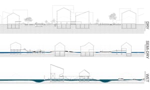
The aerial map above shows flooding in New Mastic in 2050 and, on the right, in New Mastic in 2050 after the proposed future development. Development on high, dry ground would be densified while homes in wet areas would evolve into a new elevated neighbourhood, built along docks.
They proposed freezing future development on flood plains in favour of focusing new housing in the neighbourhoods of Brooklyn, Queens, Long Island and New Jersey along “corridors” and transit spines inland on higher ground.
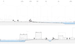
The team reimagined The Bight, the notch in the region’s coast where ocean currents pile sand, as a new “landscape economic zone” that would blur the hard line between the city and the sea and create new spaces for habitation, conservation, work and play.
These cross-sections show how Segal and Drake’s team envisage buildings could exist on the shifting threshold of water and land. Click on the images to expand and see more detail
“Rather than futilely trying to hold the line, the zone’s mantra is ‘receive, protect, adapt’,” said Segal and Drake.
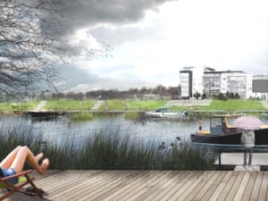
Per their vision, the coastline would be transformed into “the new urban frontier” with a vanishing barrier island at Sea Bright, NJ, by 2030; a retirement walkable community at Mastic Beach in NY by 2050; and New York City’s “new sunken central park” at Jamaica Bay by 2067.
BERMS WITH BENEFITS: A BARRIER WITH BIKE LANES AND BRT TOO
The stakes of failing to adapt to flood risk were made clear by Hurricane Sandy in 2012, which caused the deaths of 147 people and cost the US more than $50bn in damage.
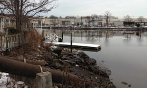
One of the worst-affected areas was Meadowlands in New Jersey, a low-lying wetland basin bisected by the Hackensack river.
During the hurricane it was impossible to pump out water because of tidal flooding on the other side of the dike, and the area was devastated: houses filled with water, cars floated away, residents had to be rescued with boats, and critical infrastructure failed.
Kristian Koreman, a co-founder of ZUS, a Rotterdam-based architectural practice, says development had failed to take into account the local ecology.
“By neglecting the fact that they were building in a swamp, they forgot that it was a tidal area,” he says. “You can see that the water goes up and down every day, but with a real storm like Sandy, and a tidal flood plus heavy rain, water came from all sides and there was no way to escape that.”
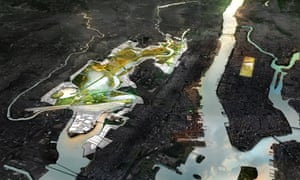
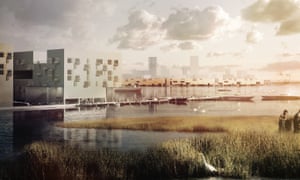
In response to Sandy, ZUS partnered with MIT’s Center for Advanced Urbanism and De Urbanisten to devise New Meadowlands: a masterplan for combining flood resilience with recreational amenities through marshes and a system of parallel raised banks called berms. (The aerial rendering is shown at the top of this article.)
Between the outer berm and the sea, the restored wetlands would soak up seawater and slow down tidal waves, preventing them from hitting the dikes at high speed. The stretch of berms would serve as a wildlife refuge, filling up with rainwater during periods of heavy rain before draining out. And on the insider of the inner berm, ditches and ponds would retain rainwater, preventing it from causing sewers to overflow.
The first pilot project will focus on the towns of Little Ferry, Moonachie and Carlstadt, with $150m in funding from the US Department Housing and Urban Development.
Given the triple whammy of climate change, increasing urbanisation and budget constraints, infrastructure projects now have to serve multiple purposes: Koreman says the team were under pressure to deliver the most value per dollar possible.
Their plan includes a huge recreation zone, as well as bike lanes and a rapid transit bus lane running across the top of the berms to better connect Meadowlands to New York. ZUS sees its design as “berms with benefits”.
FLOATING PODS AND BEYOND
Koen Olthuis, the founder of Waterstudio, a Dutch architectural practice that builds exclusively floating and amphibious structures, believes the way to encourage flood resilience is to make sure it’s almost overshadowed by those other benefits.
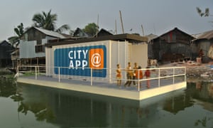
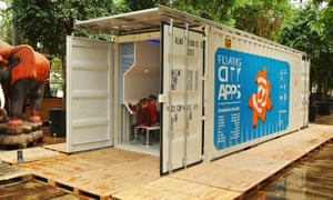
Olthuis is trying to improve living standards in waterside slums by providing vital functions such as education, sanitation and power in floating shipping containers built on foundations made of thousands of waste plastic bottles. He calls the units “city apps” as they are easy to install and launch. Since they can be moved, they can be granted a temporary licence by city governments that normally prohibit development in illegal settlements; and because they float, they entice investors who would ordinarily shy from investing in a flood plain.
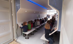
A City App used as a classroom
The first major project is in Korail, a slum on the waterside in Dhaka, Bangladesh, where five units will be arriving in October: a classroom, a sanitation unit, a kitchen and a battery pack connected to a floating solar field.
Olthuis says he works with nature, rather than treating it as a threat – which means letting water flow where it wants, and using floods as a catalyst for more flexible urban development. He talks of relieving crowding in cities by building amphibious architecture on flood plains, or augmenting a city with pop-up floating structures on waterways – concert halls, stadiums, even rescue and relief units during disasters.